Here in Vancouver, Washington we’re lucky to be surrounded by so much natural beauty. So when the weather is nice, it’s great to get out and take a walk on one of the many trails that our area has to offer. In this blog post, we’ll cover some of the best walking trails in Vancouver. Here’s our list of the best trails, along with photos, distances, locations, and links to trail maps.

Image source: City of Vancouver
Trail Name: Columbia River Renaissance Trail
Length: 5 miles
Location: Trailheads at Esther Short Park and Wintler Park
Link: https://www.cityofvancouver.us/parksrecculture/page/columbia-river-renaissance-trail-5-miles
Trail Map: https://www.cityofvancouver.us/sites/default/files/fileattachments/parks_and_recreation/page/1737/renaissancetrail.pdf
The Columbia River Renaissance trail is a 5-mile-long waterfront trail that follows the north bank of the Columbia River. From this trail, you can get stunning views of the Columbia River and pass by shops, restaurants, and shipyards. The trail runs from downtown Vancouver to Wintler Park and connects to the Discovery Historic Loop Trail.

Image source: City of Vancouver
Trail Name: Discovery Historic Loop Trail
Length: 2 miles
Location: 115 SE Columbia Way, Vancouver WA
Link: https://www.cityofvancouver.us/parksrecculture/page/discovery-historic-loop-trail-2-miles
Trail Map: https://www.cityofvancouver.us/sites/default/files/fileattachments/parks_and_recreation/page/1707/discovery.pdf
Also located in Downtown Vancouver, the Discovery Historic Loop Trail is a 2.3 mile loop that connects to the Columbia River Renaissance Trail and passes by many of Vancouver’s historical sites. Along the trail, you’ll find the Fort Vancouver National Historic Site, Officer’s Row, the Pearson Air Museum, Providence Academy, and Esther Short Park. With so many interesting destinations along the way, you can spend a whole day on the trail and really explore what Vancouver has to offer.
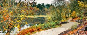
Image credit: City of Vancouver
Trail Name: Burnt Bridge Creek Trail
Length: 8 miles
Location: NE 97th Ave between NE 18th St and NE 16th St.
Link: https://www.cityofvancouver.us/parksrecculture/page/burnt-bridge-creek-trail-8-miles
Trail Map: https://www.cityofvancouver.us/sites/default/files/fileattachments/parks_and_recreation/page/1704/bbctrail.pdf
For a longer jaunt, check out the Burnt Bridge Creek Trail. This 8-mile-long trail passes through a variety of landscapes along the Burnt Bridge Creek Greenway. This is a hard-surfaced and flat trail for an easy stroll. Expect to see some great examples of Pacific Northwest features, from open grasslands to dense forests. Because of the length of the trail, there are several trailheads to start from – consult the links above for details.
Trail Name: Salmon Creek Greenway Trail
Length: 3 miles
Location: Trailhead at Salmon Creek Greenway Park
Link: https://clark.wa.gov/public-works/salmon-creek-regional-park/klineline-pond
Trail Map: https://clark.wa.gov/sites/default/files/dept/files/public-works/Parks/Salmon_Creek_Greenway_Trail.pdf
This 3 mile trail is a popular start or end to a day at the Salmon Creek Greenway Park. It runs along Salmon Creek, through wetlands and forested areas. Even though it’s within our city limits, it’s a great place to spot wildlife! Migratory birds, deer, coyotes, rabbits, opossums, raccoons, and beavers are regularly seen by hikers on the trail.
Trail Name: Cougar Trails Loop
Length: 6 miles
Location: Washington State University – Vancouver Campus
Link: https://www.vancouver.wsu.edu/about/cougar-trails
Trail Map: https://www.vancouver.wsu.edu/sites/www.vancouver.wsu.edu/files/uploaded-files/cougar-trails-map.pdf
The Washington State University campus in Vancouver is home to another one of our favorite trails. The Cougar Trails are a six mile long network of trails on campus that pass by campus buildings as well as natural areas adjacent to campus. There are four color-coded loops: Green (1.3 miles), Orange (1.3 miles), Blue (2.5 miles) and Red (4.6 miles). Some trails are paved, some are cedar chipped, and some are dirt trails. You don’t have to be a student to enjoy these trails – they’re open to the public year-round.
Conclusion
Any one of these trails is a great choice to get out and enjoy some fresh air and natural surroundings. Be sure to pack plenty of water, snacks, and some comfortable shoes. See you out on the trail!