Vancouver, Washington’s location on the north bank of the Columbia River gives local hikers quick access to Gorge cliffs, waterfalls, old‑growth forests and alpine meadows. Avid hikers can find the trails below all within an easy drive from Vancouver. For each hike you’ll find essential logistics—distance, notable sights and difficulty—plus a link to the park’s official site for the most up‑to‑date details.
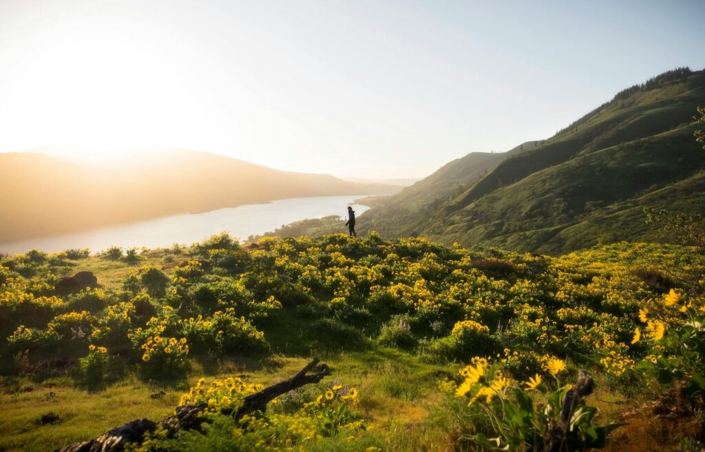
Hamilton Mountain (Beacon Rock State Park)

Image source: Wikimedia Commons
- Location: Beacon Rock State Park, about 35 mi east of Vancouver along WA‑14.
- Trail distance: The state‑park trailhead guide describes two main routes to the summit. After crossing Rodney Falls, the direct route reaches the 2,438‑ft summit in 1.7 mi. Longer variations include the Hardy Creek/Equestrian Trail loop (around 6–8 mi total) and shorter side trips to Rodney Falls and the Pool of the Winds.
- Difficulty: Steep grades and exposed cliffs make this hike challenging.
- Sights & scenery: The trail starts in old‑growth Douglas‑fir forest and passes Rodney Falls, Hardy Falls and the misty Pool of the Winds. Beyond these waterfalls the route climbs through wildflower meadows to panoramic views of the Columbia River Gorge, Bonneville Dam and Cascade peaks.
- Official information: Hamilton Mountain Trailhead guide (PDF).
Beacon Rock Trail (Beacon Rock State Park)
Image source: Wikimedia Commons
- Location: Beacon Rock State Park
- Trail distance: Beacon Rock Trail is a 1.8‑mile round trip with a 750‑ft elevation gain. The route ascends a sheer basalt monolith via 52 switchbacks, creating a moderate but constant grade.
- Difficulty: Beacon Rock Trail is moderate difficulty, and suitable for all ages. However, the trail is not ADA‑accessible and not stroller‑accessible.
- Sights & scenery: Built directly onto the cliff, the trail offers nearly continuous views of the Columbia River Gorge. Railings and bridges throughout the route make for an exciting hike.
- Official information: Beacon Rock State Park official website
Cape Horn Loop (Columbia River Gorge National Scenic Area)

Image source: US Forest Service
- Location: Skamania County on the Washington side of the Columbia River Gorge, east of Washougal.
- Trail distance: The Cape Horn Trail is a strenuous, 6-mile loop. The Forest Service notes that hikers can hike this trail only between July 16 and January 31. During the annual peregrine falcon closure (Feb 1–Jul 15), you can still hike about 2 miles to the Nancy Russell Cape Horn Overlook.
- Difficulty: Sections of the loop traverse steep cliffs, which can make the hike quite difficult and strenuous.
- Sights & scenery: Classic Gorge vistas abound—look east up the river, stop at viewpoints such as Pioneer Point and Cigar Rock, and watch for waterfalls, wildflowers and nesting raptors. The lower loop descends past Cape Horn Falls when open.
- Official information: Cape Horn Trail #4418 – U.S. Forest Service.
Silver Star Mountain via Silver Star Trail #180 (Gifford Pinchot National Forest)

Image source: Wikimedia Commons
- Location: Gifford Pinchot National Forest north of the Columbia River Gorge. The main access is the Silver Star Trailhead at the end of Forest Road 4109, about 30 mi from Vancouver. High-clearance vehicles are required to reach the trailhead – the road is not recommended for passenger cars.
- Trail distance: The Forest Service describes Silver Star Trail #180 as a 5‑mile trail that gradually ascends past wildflower meadows and huckleberry slopes toward Silver Star Mountain. The trail intersects several connectors—Ed’s Trail #180A, Chinook Trail #180B and Sturgeon Rock Trail #180C—before a short 0.25‑mile summit spur (#180D) leads to the 4,390‑ft peak.
- Difficulty: The trail is primitive with rock scrambles, steep climbs, and loose rocks. This makes for a difficult hike suitable for experienced hikers.
- Sights & scenery: Expect sweeping ridge‑line views; on clear days you can see Mount Hood, Mount Adams, Mount St. Helens and even Mount Rainier. In summer the meadows explode with wildflowers; Ed’s Trail passes a natural rock arch and offers airy traverse along a rugged ridge.
Official information: Silver Star Trail #180 – U.S. Forest Service and Silver Star Trailhead – U.S. Forest Service.
Moulton Falls Regional Park (Clark County)

Image source: Wikimedia Commons
.jpg)
- Location: East of Battle Ground in Yacolt, WA (about 20 mi northeast of Vancouver) along the East Fork Lewis River.
- Trail distance: Clark County’s park page notes a 2.5‑mile trail connecting Moulton Falls Regional Park to Lucia Falls Regional Park, and access to the longer 7.5‑mile Bells Mountain Trail.
- Difficulty: Trails are wide, gentle and flat. It’s a low-difficulty trek suitable for hikers of all skill levels and abilities.
- Sights & scenery: The park spans both sides of the river with lava‑flow rock formations, historic Native American meeting grounds and a picturesque arch bridge over the East Fork Lewis River. Visitors can also reach waterfalls and enjoy swimming in the river during warmer months.
- Official information: Moulton Falls Regional Park – Clark County Public Works.
Practical Tips To Enjoy Your Hikes
- Pass requirements: Washington State Parks (Hamilton Mountain and Beacon Rock Trail) require a Discover Pass for parking. The Forest Service trailheads for Silver Star do not charge a fee, but parking at the Grouse Vista trailhead (managed by the state) may require a Discover Pass.
- Seasonal considerations: The Cape Horn Trail’s lower loop is closed Feb 1–Jul 15 for peregrine falcon nesting. High‑elevation trails like Silver Star may retain snow until mid‑June. Check weather conditions before you go to ensure that the trail you want to hike is open.
- Road conditions: Forest Road 4109 to Silver Star Trailhead is rough—high‑clearance vehicles are recommended. For a smoother drive, many hikers opt for the Grouse Vista Trailhead on DNR roads.
- Pets: On-leash dogs are allowed on some trails. Check official park service websites for specific rules regarding pets on trails.
Closing Thoughts
Within an hour of Vancouver you can stand atop a volcanic monolith, peer down on thundering waterfalls, ramble through wildflower meadows and stroll along a riverside railbed. These five hikes showcase the diversity of southwest Washington’s landscapes. Always check the official websites linked above for current conditions and trail closures before heading out. Happy hiking!